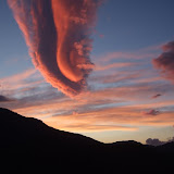
I completed the GR11 on Monday 26th July at a scorching and windy Cap de Creus,
23 days since leaving Cabo Higuer on the Atlantic Coast. My route was about 825km with 39,000 metres of ascent.
Photo albums
|
Route on Google maps
View GR11 in 23 Days in a larger map
Friday, July 30, 2010
Thursday, July 29, 2010
GR11 Photo Albums
Click thumbnails to view photo galleries


Tuesday, July 27, 2010
Getting home
Arriving at Cap de Creus is not quite the end of the story. I still had the small matter of getting home.
I had no clear plan of what to do next, so asked at the lighthouse tourist information centre. It sounded like the best bet was to walk around the coastal path to Cadaqués and then jump on a bus.
The hike to Cadaqués took just over 2 hours. The coastal path was heavily overgrown with thorn bushes in many places, and didn't look that well used. I reached Cadaqués at 4.15pm and was sitting on the bus to Figueres at 4.45pm. The Figueres bus terminates right next to the railway station from where I caught the train to Girona.
By 7.30pm I was in Girona and had found a room at the low-key Europa Hotel, close to the train and bus stations.
The following day, Tuesday 27th July, I spent the morning in Girona before catching a bus to the airport and flying to Prestwick with Ryanair, from where thankfully Ellie picked me up.
When I'd planned the trip, I had no clear idea how long the GR11 hike would take, and had estimated 26 days. Therefore my original flight from Girona was booked for Friday 30th. However when I reached Requesens in that gale force wind on Saturday 24th, it was pretty clear by that stage I would complete in 23 days, so I'd texted Ellie to book me another flight, since I didn't fancy sitting around for 3 days in Girona waiting to get home.
Monday, July 26, 2010
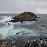
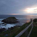
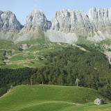
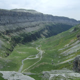
Day 23 - Port de la Selva to Cap de Creus
18km, 500 metres of ascent
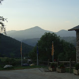
Today was a strange little coda to the trip. It really felt like I'd completed the traverse of the Pyrenees yesterday, but the GR11 demands that you hike out to the barren wasteland of Cap de Creus to complete the route.
Today was a strange little coda to the trip. It really felt like I'd completed the traverse of the Pyrenees yesterday, but the GR11 demands that you hike out to the barren wasteland of Cap de Creus to complete the route.
I had a super-dawdly start and didn't leave the campground until 8am, and then immediately stopped in Port de la Selva for a café con leche and croissant. I was getting a bit worried that the day was slipping away, and my foot was off the gas.
But once I was out of Port de la Selva, the kilometres ticked by, and it wasn't long before I was on the final stretch of tarmac road leading up to Faro Cap de Creus lighthouse, surrounded by cars and tourists.
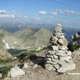
At the lighthouse I could see continuing red and white markers. Not quite there yet. I followed the paint marks through ever more jaggy rocks, towards the true headland.
Soon I was alone again reaching the final red and white mark; then a cairn; then a cliff into the sea. This really was the end of line.
For 23 days, every footstep had been leading to this point, but now the journey was over. I was off duty. I was just another tourist bumbling around on the rocks.
View GR11 - Day 23 in a larger map
Sunday, July 25, 2010
Day 22 - Requesens to Port de la Selva
54km, 1350 metres of ascent
After the fantastic long day yesterday, I set out this morning feeling absolutely done in, with rock bottom energy levels and struggling for motivation.
After the fantastic long day yesterday, I set out this morning feeling absolutely done in, with rock bottom energy levels and struggling for motivation.
I got virtually no sleep last night with the violent gusting winds, and the wind has still not abated, so Requesens is feeling a dour cheerless place.
I decide I need to strip off some clothes to myself going, and the second I stop two young German guys storm on past. This is just the jolt to the system I needed, since I hadn't seen any hikers for about 3 days.
I quickly catch them up, and we switch places a few times, but it is far too windy to be able to speak, however a bit later down the trail we re-convene and enjoy chatting as far as Sant Quirze de Colera, which makes the miles fly by.
The Germans take a siesta at Sant Quirze de Colera, and I visit the bar for a drink and to discretely eat the rest of my food. It is just after 1pm when I start hiking down the road towards Vilamaniscle in the full scorching mid-day sun. I am feeling quite frazzling, and the fatigue suddenly swamps me now that I'm back on my own.
I am struggling to walk in a straight line down the road, and the screaming wind means I can't hear if any cars are coming, so it doesn't feel entirely safe. I stagger onwards until I finally concede defeat and slump under a tree to rest my eyes and brain. I only doze for a few minutes, but suddenly feel completely awake again just from allowing my system to shut down.
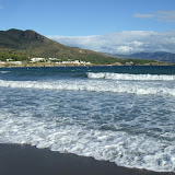
Vilamaniscle comes and goes. I am passing vineyards now and entering a new arid type of landscape. It reminds me of California. I stop at Sant Silvestre briefly, but I have run out of water and need to get to Llançà for a drink. I pass through the Coll de les Portes 230m, and the Mediterranean Sea is spread out before me. It feels hard to believe that I have just walked across Spain.
Arriving in Llançà I feel frazzled from the scorching heat and scouring wind, and dive into a blissful air-conditioned supermarket buying one of every type soft drink. Kilian Jornet conveniently called it a day at Llançà on his recent trans-Pyrenees jaunt, however the GR11 carries on for another 27km, with almost another 1,000 metres of ascent, if you want to finish at Cap de Creus.
I tried to enjoy the 500m climb after Llançà to reach Sant Pere de Rodes. Suddenly I was surrounded by cars and regular tourists. Back into civilisation.
The descent from Sant Pere de Rodes monastery to Port de la Selva slices through all the hairpins and drops you right at the seafront, and 22 days after leaving the Atlantic, I had reached the Mediterranean.
I still needed to hike a good couple of kilometres along the coast away from Port de la Selva to find the Port de la Vall Camping, but at last I could stop and relax.
View GR11 - Day 22 in a larger map
Saturday, July 24, 2010
Day 21 - Albanyà to Requesens
52km, 1690 metres of ascent
What a difference a decent night's sleep makes. This morning the world seemed a much brighter place. I packed up early and left before Bassegoda Park was awake.
What a difference a decent night's sleep makes. This morning the world seemed a much brighter place. I packed up early and left before Bassegoda Park was awake.
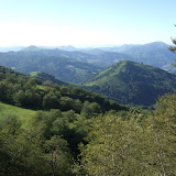
The trail from Albanyà quickly gains height via a pista before following a mix of track and trail through wonderful pine forests. So much more scenic than yesterday, and much warmer, with full sunshine all day.
The trail northwards was fairly uneventful apart from one minor faux pas where the GR11 signs sent me around in a circle.
I stopped for a drink at Moli d'en Robert, but the barman seemed uninterested in serving me, so I just carried on towards Maçanet de Cabrenys.
On reaching the edge of Maçanet de Cabrenys I was in two minds whether to go into the town centre, but I thought it would just waste time, so instead turned right in the direction of Darnius, then cutting a corner through cork oak forests to pick up the road to La Vajol. The guidebook suggested following the road to La Vajol as being far easier than attempting the waymarked GR11, so I took this option,
It was still quite a hilly winding road to reach La Vajol, where I made a brief café stop, and actually got served this time.
After La Vajol, the GR11 is really starting to run out of inspiration. The route has given up with following the border hills, and instead follows a tedious tarmac road for several kilometres before taking pistas through scrubby farmland dotted with fig trees and cactuses.
The landscape is suddenly starting to look Mediterranean.
It is after 6pm when I cross the busy E-15 motorway to reach La Jonquera. The place looks like one enormous truck stop, lined with the most enormous supermarkets and junk shops. I need to get through this hell-hole as quickly as possible, to stand any chance of reaching Requesens tonight, which is still a good 3 hours away.
I hurtle round one of the supermarkets which is twice the size of some of the villages I've seen on my trip. Then march down into the old town hoping that I might pick up the GR11 markers again. To my amazement I look down an alleyway and spot a marker, and hope that I am now back on route. I scoff down as much of the food and drink as I can, then brace myself for the 600m climb up the ridge to Puig dels Falguers 778m.
I am extremely pressed for daylight, setting off up this climb just after 7pm. I try to move as fast as possible, since I don't think there will be any camping before Requesens. The trail is rocky and overgrown and not all that clear, so it requires 100% concentration.
As I get higher on the ridge, the sun is dropping low on the horizon into banks of cloud, and the wind is picking up to the point of seriously impeding progress. By the time I reach Puig dels Falguers I can barely stand in the screaming crosswinds.
It's just before 9pm when I reach Coll de l'Auleda, and although it's getting cold and dark and horrifically windy, I can partially relax now since it is an easy downhill pista to Requesens. Plus I get a boost from seeing a magnificent full moon rising into a cluster of pink clouds above the coastal town of Roses. I love seeing sights like this when I'm the only person on the hill, it feels like a special reward for bending the rules a bit.
I dilly dally on the descent taking photos of the full moon, which means it is pitch dark when I reach Requesens, but I find the first bit of flat ground and carefully pitch the tent in a buffeting changeable wind, trying to make sure nothing blows away. As soon as the tent is up I realise I have company from a large bull, but there is no way I have the energy to make alternative sleeping arrangements, so I just hope that I won't be trampled in the night.
I spend the night listening to violent gusts of wind approaching and then slamming into the side of the tent.
View GR11 - Day 21 in a larger map
Friday, July 23, 2010
Day 20 - Can Planas to Albanyà
39km, 1380 metres of ascent
By 6am I was shattered from the electric storm lasting all night. Needless to say, the Can Planas woman didn't bring me a cup of tea, so I packed up the soaking tent in now drizzly rain, and plodded on down the muddy slippery trail to Beget.
By 6am I was shattered from the electric storm lasting all night. Needless to say, the Can Planas woman didn't bring me a cup of tea, so I packed up the soaking tent in now drizzly rain, and plodded on down the muddy slippery trail to Beget.
It was 9am when I reached the ancient little village of Beget and of course there was nothing open and no shop. I went to the Hostal El Forn but there were no signs of life. Then to my astonishment the Can Jeroni actually appeared to be opening for business. I felt a bit ridiculous going into the restaurant in my stinking wet clothes, but the staff were very friendly and helpful, and brought me this morning's newspaper showing the strange outcome of yesterday's Tour de France stage on the Col du Tourmalet where Contador put his arm around Schleck as they crossed the line, like it was all planned.
The café con leche at Can Jeroni was good quality but nowhere near enough, so I went back to Hostal El Forn which had now woken up and grabbed another coffee. As I checked out the local newspaper, I saw a familiar site on the front page. It was the view down onto Núria where I had started yesterday, but the photo showed Kilian Jornet romping to victory in the Olla de Núria race that happened 3 days before I arrived.
Anyhow, I didn't need reminding of superstars who can run across the Pyrenees in 9 days. I needed to get moving in the direction of Albanyà.
Today's hike was a strange contrast to all the previous days. The weather and my lack of sleep probably didn't help much, but the walking was just unrelentingly dull and depressing. A muddy slippery track surrounded by dripping trees, creating a general feeling of claustrophobia and disorientation.
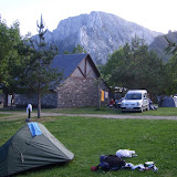
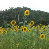
The only cheerful thing that happened all day was that the sun came out briefly as I walked past a field of sunflowers at Can Ferrers. Luckily just before Albanyà, there is a fantastic fully-equipped campsite called Bassegoda Park that even had an open supermarket, so I spent a quiet night here.
View GR11 - Day 20 in a larger map
Thursday, July 22, 2010
Day 19 - Núria to Can Planas
38km, 1900 metres of ascent
Yesterday was a day of suffering, but this morning I awoke in the comfortable surrounds of the Hotel Vall de Núria. White towels. En suite bathroom. Breakfast buffet. What more could you ask for?
Yesterday was a day of suffering, but this morning I awoke in the comfortable surrounds of the Hotel Vall de Núria. White towels. En suite bathroom. Breakfast buffet. What more could you ask for?
I made the most of the self-serve breakfast with endless rounds of toast, plain yoghurt and café con leche. It was strange to be surrounded by normal people all of sudden. None of whom looked like they were mid-way through a cross-continental jaunt.
Once the waitresses appeared to be losing patience with me, I returned to my room, grabbed my backpack, checked out and then spent some time hunting for the GR11 continuation trail, which in fact turned out to be the very obvious pista heading north-east.
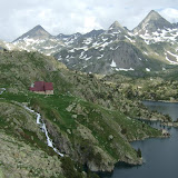
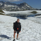
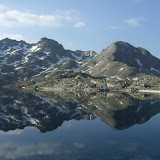
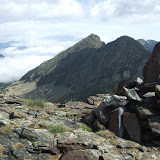
After feeling totally ill yesterday, I was a bit trepidacious whether my stomach would be OK, and whether any energy would have returned, so I set off slowly on the 700m climb to Coll de Noufonts. Thankfully as soon as I got going, the climb felt effortless, and I was soon at the 2645m col.
The next 3km follows the French-Spanish border along a high exposed undulating ridge, with great views north into France. This was quite pleasant, apart from the screaming wind that was trying to knock me off my feet. Once off the ridge it didn't take long to reach the Refugi d'Ulleter 2200m where I stopped for a coffee, and to get out of the cold misty conditions.
There was an option from Refugi d'Ulleter to follow the HRP high-level route to reach Molló, thereby missing out Setcases. But given the thick mist and imminent rain, this was not an appealing option, so I chose the straightforward descent to Setcases with the rain setting in.
Once at Setcases, I found a bar showing Stage 17 of the Tour de France from Pau to Col du Tourmalet. When I arrived, the riders were nearing the summit of the Col du Soulor, but still had 58 kilometres to go. The weather looked lousy. The riders were putting on jackets as they crossed the col. I treated myself to a bistec and greasy bread, but then thought I should get a move on and head over the hill to Molló.
A young Czech hiker who had just arrived from Molló warned me that the route would be tricky to follow in the mist. I liked the sound of a challenge so set off from Setcases, probably around 4.30pm.
As promised the route was extremely tricky to follow in the mist and rain, and I repeatedly lost the trail and had a few stressful encounters with cattle. But eventually the rain and mist cleared just as I was dropping into Molló at 8pm. My plan had been to stop here, but there were no obvious lodgings or decent looking bar/restaurants, so I just kept walking on autopilot.
I crossed the Riu Ritort and climbed over the Coll de la Boixera, now in grassy farmland. I was now descending towards Beget but it was almost completely dark. I dug out my headtorch and was thinking I really need to stop soon.
Passing the farmstead of Can Planas barking dogs alerted the owner to my presence, and the woman offered some flat grass beside the house for me to camp on. I was aware that the weather was looking pretty unsettled so asked about staying in the house, which offers accommodation. Unfortunately the woman refused to offer me any shelter since she didn't have a bed made up, and she didn't know I was coming.
I thought these were pretty lame excuses, and no sooner had I got the tent up than the most almighty electric storm broke out. My first thought was "thank god I'm not hiking down the trail to Beget in the dark, or I'd be soaked in seconds", but my second and longer-lasting thought was "how can that woman possibly leave me lying out here in this torrential rain when there is a perfectly good house 2 metres away". In fact the second thought pre-occupied me for the next 7 or 8 hours, since there was no chance of getting any sleep with thunder and lightning all night, and the heaviest rain I have ever experienced.
View GR11 - Day 19 in a larger map
Wednesday, July 21, 2010
Day 18 - Planoles to Nuria
20km, 1100 metres of ascent
Last night I had started to think that a 22-day finish might be on the cards, however today didn't go quite as planned. In fact things went a bit wrong right from the start.
Last night I had started to think that a 22-day finish might be on the cards, however today didn't go quite as planned. In fact things went a bit wrong right from the start.
Since my watch had packed up on Day 1, my policy for getting up in the morning was to wait until the first signs of light percolated through the walls of the tent, and then I was start stuffing everything away.
So this morning I woke up, saw light filtering in from outside, thought I'd make a nice early start, packed everything away, crawled out of the tent, and realised it was still the middle of the night. What an idiot. The light was coming from one of the campsite nightlights.
Of course a few hours later when it was really morning, I didn't feel like getting up!
My breakfast consisted of a handful of broken biscuits and some water before starting up the 700m climb to Collet de les Barraques. I could tell something was wrong straight away. It was like having hollow legs. I tried to ignore the problem and use mind over matter to kept some rhythm going, but I was barely moving at all.
My stomach was not happy, and when I reached the col my trip to the toilet confirmed what the problem was. I had some sort of horrible food poisoning, just like being in Nepal, when you get very little warning of your next toilet stop!
The next few hours were a bit of a blur of repeatedly losing the trail and repeated bouts of diarrhoea. At one point I suddenly woke up and realised I had fallen asleep lying next to the trail. I thought this is not a good sign, and must try to keep moving.
When I finally reached the funny purpose-built mountain resort of Nuria, I made a beeline for the first patch of grass, crumpled to the ground, and just lay there.
I had no idea what to do next, but eventually summoned the energy to locate the camping area, pitch my tent and crawl inside and fall asleep, despite it being the middle of the afternoon. Later I woke up feeling cold and achey. I had nothing to eat, but still felt awful so went to the hotel in search of inspiration.
I located the hotel doctor and had a consultation. The doctor gave me a re-hydration drink plus paracetamol and loperamide hydrochloride capsules, and I was told to go to bed without any food, so I retrieved my tent and checked into the hotel and treated myself to a wonderful night's sleep in total comfort.
View GR11 - Day 18 in a larger map
Tuesday, July 20, 2010
Day 17 - Malniu to Planoles
41km, 1100 metres of ascent
This was one of the more unpleasant starts to the day. All my kit was sopping wet. The air outside was thick with mosquitoes. And the tent was sodden with condensation.
This was one of the more unpleasant starts to the day. All my kit was sopping wet. The air outside was thick with mosquitoes. And the tent was sodden with condensation.
I got 100% ready inside the tent, with everything packed and shoes on, à la jumping off the boat in the Island Peaks Race, then leapt out and packed the tent as fast as humanly possible, whilst being chewed to bits by mosquitoes.
My wildcamp was above 2,000 metres, so it was quite cold first thing, and the ground was wet with early morning dew. The first few kilometres crossed open meadows on indistinct trails past grazing horses. I had to repeatedly double and triple check I was going the right way.
Lower down eventually the trail became more obvious and I dropped into the village of Guils de Cerdanya. One of many strange-looking, purpose-built clusters of holiday homes, with nobody around and no facilities.
I continued down the road past Saneja through cultivated farmland with colourful fields of crops and poppies. When I reached the campground just past Saneja I stopped for about 20 minutes to spread out all my kit on the ground to dry it out in the sun, before continuing to Puigcerda.
It wasn't obvious from a distance, but the town of Puigcerda is perched on a steep hill which forms a natural fortress. It was a steep slog to get up into the town centre, and not easy to find a supermercado, and I was getting a bit panicky that there was still a huge stage to do in the afternoon and it was almost mid-day.
I took a compass bearing to find my way out of the confusing town of Puigcerda and then found the continuation of the GR11 in the direction of Age, another strange holiday-home village. The weather was looking a little unsettled as I climbed to Coll Marcer. I stopped for a while to speak with an American guy near Coll de la Creu de Meians before promptly missing the trail and ending up trashing cross country for a while to re-gain the pista.
The final section past Dorria to Camping Can Fosses looks like nothing on the map, but turned out to be heavily overgrown with brambles and thorn bushes, making for slow progress and much cursing.
It was a major relief to arrive at Camping Can Fosses and relax with ice cream, cold drinks and a beer or two. Of course there was no proper food to eat, but I hadn't really expected any.
View GR11 - Day 17 in a larger map
Subscribe to:
Posts (Atom)


